Altitude-Azimuth Coordinate system
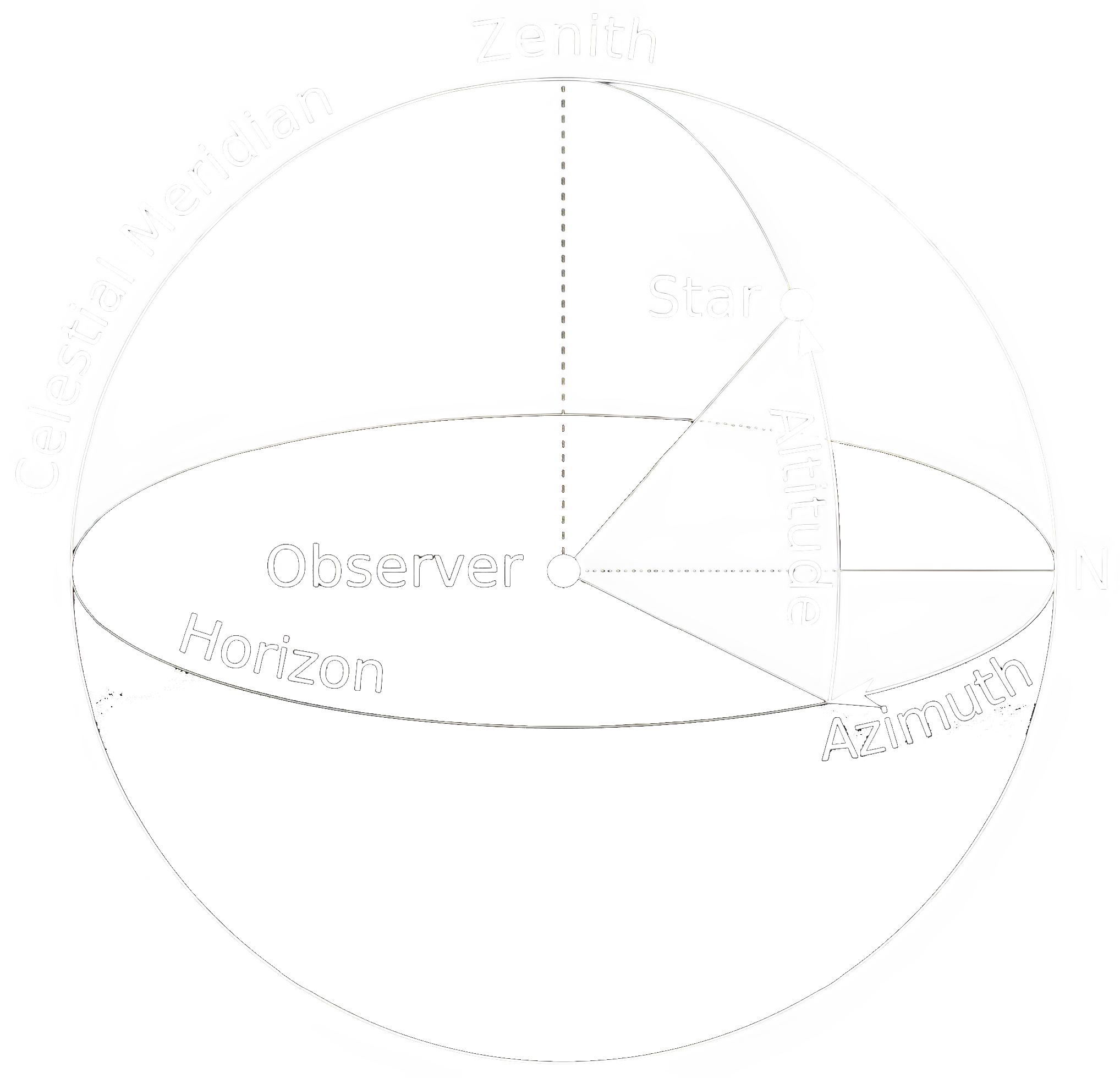
The Altitude-Azimuth coordinate system is a local coordinate system that is centered on the observer. The altitude is the angle above the horizon, and the azimuth is the angle measured along the horizon from the north point. The altitude ranges from 0 to 90 degrees for visible objects, and the azimuth ranges from 0 to 360 degrees.
The altitude and azimuth are measured from the observer’s location, so they are different for every observer. The altitude and azimuth are the most intuitive coordinates for observers, but they are not the most convenient for calculations.
The following diagram shows the Altitude-Azimuth coordinate system (Credits: TWCarlson):
The main disadvantage of the altitude-azimuth coordinate system is that it is purely local, and hence bound by the longitude and latitude of the observer’s view-point. Two observers at different points on the Earth’s surface will measure different altitudes and azimuths for the same star at the same time. In addition, an observer will find the celestial object’s coordinates changing with time as the celestial sphere appears to rotate.
For the purpose of calculations, you may use the following coordinates of IIT Kanpur:
- Latitude: 26.5123 degrees N
- Longitude: 80.2329 degrees E
Horizon
The horizon is the circle that separates the visible sky from the invisible sky. The altitude of the horizon is 0 degrees. All four cardinal points lie on the horizon.
Zenith
Opposite to Nadir, Zenith is the direction pointing directly above a particular location, orthogonal to the flat surface, i.e., the Earth’s local tangential plane. Alternatively, its direction can be taken as anti-parallel to the local gravity vector. Its altitude is 90 degrees with an undefined azimuth.
If you are at the Geographic North Pole of the Earth, the brightest star near the Zenith will always be the Pole Star.
Nadir
Opposite to Zenith, Nadir is the direction pointing directly below a particular location, orthogonal to the flat surface, i.e., the Earth’s local tangential place. Alternatively, its direction can be taken as parallel to the local gravity vector. Its altitude is -90 degrees with an undefined azimuth.
If you are at the Geographic South Pole of the Earth, the brightest star near the Nadir (not that you’ll be able to see it though) will always be the Pole Star.
Cardinal Points
A fancy word for the four direction, the cardinal points essentially are North, South, East and West. The cardinal points on the horizon have specific values of azimuth that are helpful references:
- N: 0°
- E: 90°
- S: 180°
- W: 270°
Hence, an observer in the northern hemisphere (like one in IIT Kanpur) can determine whether an object is rising or setting by considering the azimuth of the object, i.e., if the azimuth of the celestial object is in between:
- 0° and 180°, the object is rising
- 180° and 360°, the object is setting
If you are at the Geographic Equator of the Earth, the brightest star along the direction of the North cardinal point on the horizon will always be the Pole Star.
Meridian
The meridian is the circle that passes through the zenith and the north and south points on the horizon. The meridian is the line that divides the sky into two hemispheres, the eastern and western hemispheres. The meridian is also the line that divides the day into two halves, the morning and evening.